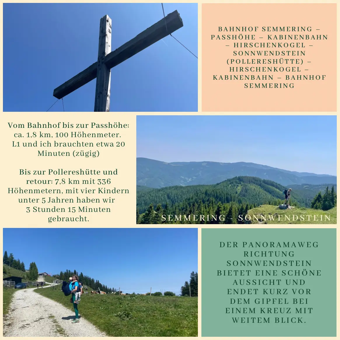
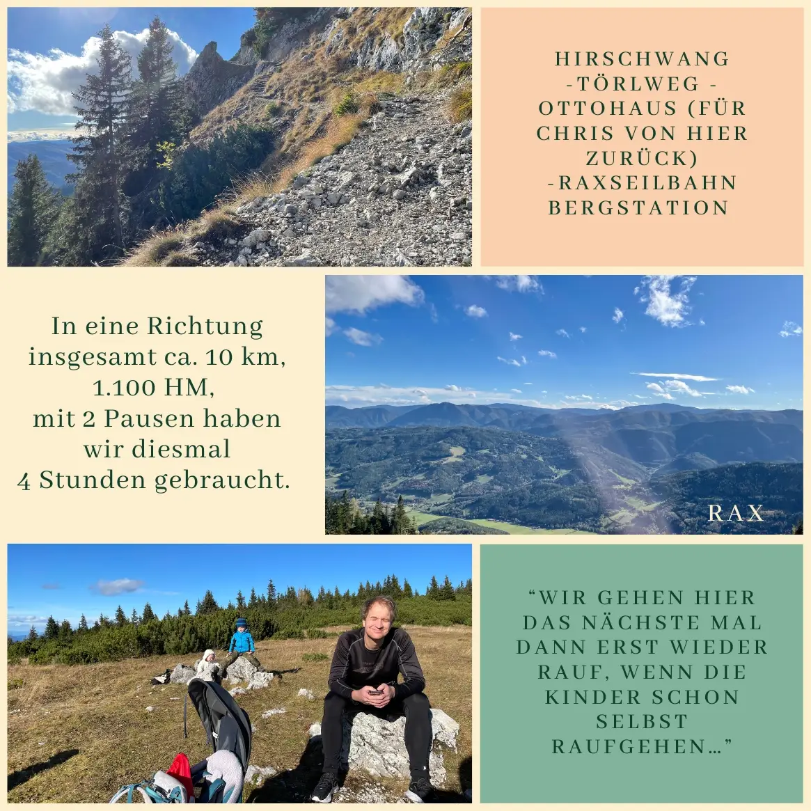
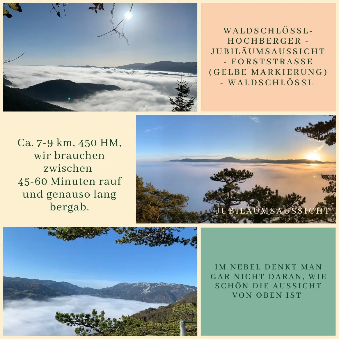
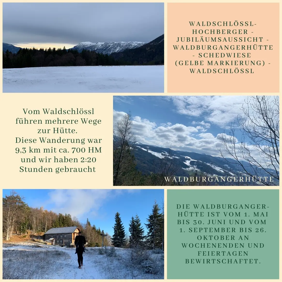
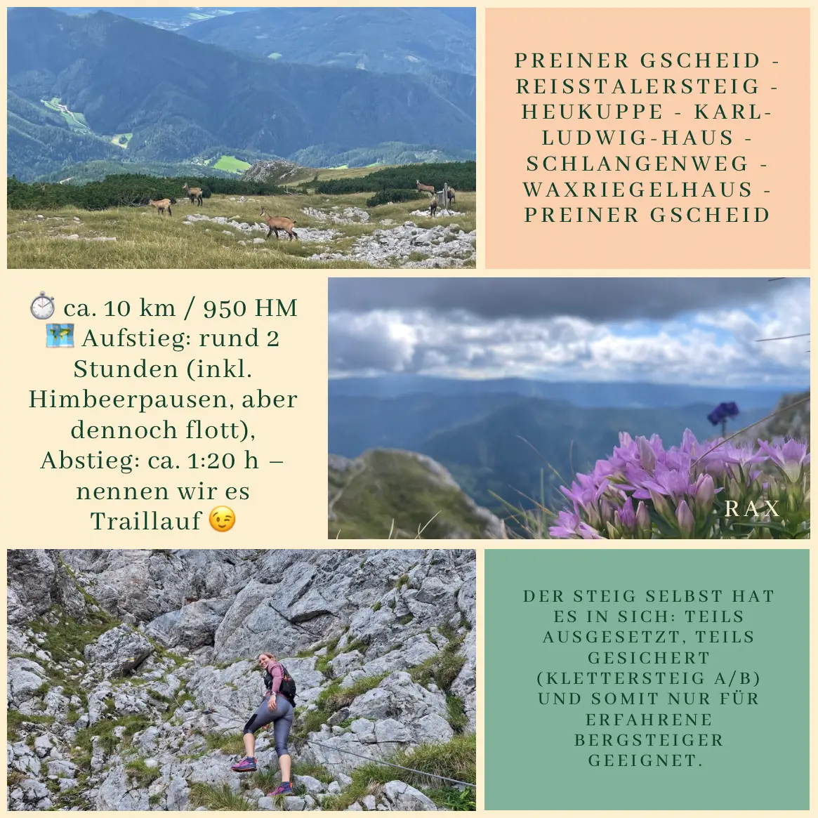
Sonnwendstein with Kids and Friends – A Waldschlössl-Style Warm-Up Before the Race Day

On what was just another working Saturday – at least according to Christian, who was busy building the greenhouse – Z and the two Ls set off to make the most of the sunshine, our Lower Austria Card, and most of all, the great company of our friends from Vienna

This day was all about tapering – with a trail running race ahead for L1 and me the next day, this hike was more of a gentle warm-up and a laid-back day (Spoiler: It wasn’t).

Our logistics worked like a charm: we rolled down to the train station by bike, had our snack on the train, L2 took a short but efficient nap, and soon we arrived in Semmering. From there, we headed towards the cable car and met up with our friends from Vienna: kids company ✅, hiking motivation ✅.

A few minutes later, the gondola took us up to Hirschenkogel – a familiar place for the kids from last year, with its awesome playground, water fun, marble run, climbing frames, and pre-lunch picnic. From there, we continued on the panorama trail towards Sonnwendstein. It’s a bit longer and steeper than the forest route, but the views are stunning – and from the big cross near the summit, you get almost the same breathtaking vista as from the actual peak. Since I had sworn just three weeks earlier not to climb that mountain again for a while (More), this was a great alternative. Everyone agreed: one summit a day is plenty 😅.

All four kids hiked with enthusiasm. We carried the little ones now and then, while the two older boys managed to walk most of it on their own. When L1 got tired of the uphill, we did what Boribon (a Hungarian bear from a children’s book) would do after falling and bumping his knee: he carried the backpack, I carried him. Or in his words:

“Mum, I’m in the front, because L2 is in the back!”

At Pollereshütte, they had tasty local dishes, plus a gluten-free and vegan lentil stew – highly recommended. After a short rest, we headed back down via the forest trail.

Finally, we took the gondola down again – and thanks to our friends, we even got a ride back to the Semmering train station. From there, it was a smooth trip home.

Route: Semmering Train Station – Passhöhe – Cable Car – Hirschenkogel – Sonnwendstein (Pollereshütte) – Hirschenkogel – Cable Car – Semmering Train Station

Hiking Distance:

From the train station to the cable car base: about 1.8 km, 100 meters elevation gain. L1 and I did it in 20 minutes at a brisk pace.

Hirschenkogel–Pollereshütte–Hirschenkogel: 7.8 km with 336 meters elevation gain. With four kids under five, it took us 3 hours and 15 minutes.

From Breitenstein to the Speckbacherhütte – A Train-Assisted Family Hike for the Tiniest Steps

Saturday. According to Chris, it’s the best workday of the week – finally “no one from the office bothers him.” Since we have two kids, it’s been harder to set off on hikes alone with them: at least one needs to be carried, plus a backpack, a bit of logistics… and still, these are the outings that turn into our fondest memories. Especially when someone joins us.

All you need to know about our immediate neighbors is that L2 counted both of their names (or something close 😅) among his first ten words. My main contribution to the hike was knowing the route and having a plan – and ensuring good company (since both boys came along). Karin (“Tári”) and Grandpa Christian (“Sztán”) brought everything else we could need: a flashlight, snacks, fruit, good spirits – basically everything a child could wish for.

Our destination was the Speckbacherhütte, where Alexandra welcomed us once again with a fantastic lunch – including vegan and gluten-free options.

We started our hike in Breitenstein, where we arrived by train – which made the adventure more exciting for the kids and shortened the climb. There’s a small playground at the hut where we took a longer break before descending toward Reichenau and walking back to the Waldschlössl from there.

This hike can be easily modified, and the hut is also accessible by car. If the weather looks uncertain, it’s worth waiting at the hut for the next train and quickly hiking down to Breitenstein. From there, it’s a mostly dry journey home.

Route: Breitenstein – Speckbacherhütte – Stojerhöhe – Reichenau an der Rax – Waldschlössl

📍 9.75 km

⛰ +390 m / –640 m elevation difference

🕒 Took us about 3 hours at a relaxed pace

The best hikes aren’t about where you go – but who you go with.

Hike to the Ottohaus – four seasons in one day

On this mild morning at the end of October, we woke up to snowfall and stormy winds – so we tried to delay our start. Just a few hours later, we were climbing uphill in bright sunshine – a completely surreal experience. The mountains are unpredictable, but that’s exactly what makes them magical.

By the time we reached the top, it was clear to both of us: we’ll only return here once the boys can hike on their own.

(Update May 2025 – Zita: Of course I’m still carrying L2 on my back.)

We met our friends at the Ottohaus – they had taken the cable car with their three kids, while we started from Hirschwang and followed the Törlweg. Not long after we arrived, Christian headed straight back: he ran down into the valley alone. I walked with the boys to the cable car station, and we descended together – and arrived at the base station at exactly the same time. We spent a total of four hours on the mountain.

📍 Distance: approx. 10 km

Elevation gain: approx. 1,150 m

Duration: 4 hours (gross)

Route: Hirschwang – Törlweg – Ottohaus – Praterstern – Rax cable car station

The most memorable hikes rarely go as planned – and that’s exactly what makes them unforgettable.

A sunset fading into the mist – a silent sunrise above the clouds 🌫🌅

We’ve recommended the hike to Jubiläumsaussicht many times – this week I tested it twice to see if you can rise above the fog. Both times, I was lucky. 🌫🌅

Fog is a rare visitor here in Reichenau – maybe because of all the wind. But growing up in Veszprém (Hungary), I still wait for those foggy November mornings with a childlike excitement, when the Rax disappears from view or the valley wraps itself in a soft mist by late afternoon.

It was 2021. Chris’s dad was visiting us, which kept Leno fully occupied – so I took the chance to head out for a quiet morning run.

I started on the path next to the Waldschlössl, turned right by the new bee hotel under construction, and cut through a short forest section instead of following the paved road. At Hochberger, the surrounding mountains began to emerge, though the hills were still cloaked in thick mist. From there, it was about 25 minutes of brisk walking to the lookout, where the first rays of sunlight gently broke through the fog – a true gift of the weather.

On the way back, I followed the yellow trail: a bit further up the blue path, then left onto the tractor road, and after about half a kilometer, I was back on familiar trails heading home to the Waldschlössl.

If you ever want to experience the peaceful silence of the fog and the slow awakening of the hills, we wholeheartedly recommend this route – short, varied, and full of surprises in every season. 🏞🍂

📍 Distance: 7-9 km

⛰ Elevation gain: approx. 450 m

⏱ Duration: 1 hour 15 minutes – 3 hours (depending on pace)

Route: Waldschlössl – Hochberger (blue trail) – Jubiläumsaussicht – yellow trail – back to Waldschlössl

Lentil soup on the summit, soft breathing in the carrier – a quick hike to Waldburgangerhütte

This time we did a brisk, scenic loop hike starting from Waldschlössl:


Jubiläumsaussicht – Waldburgangerhütte – Schedwiese, then back to the start.

The Waldburgangerhütte is open on weekends and public holidays from May 1 to June 30 and September 1 to October 26 – perfect for a well-earned rest and some refreshments at the top.

There are several ways to reach the hut from Waldschlössl – we followed the blue trail uphill. The Jubiläumsaussicht offers beautiful panoramic views. On the way back, we took the yellow-marked pathvia the Schedwiese, a wide meadow with scenic vistas. If the hiking trail feels too steep, you can switch to the forest road and take the serpentine route down.

📍 Distance: 9.3 km

⛰ Elevation gain: approx. 700 m

⏱ Duration: 2:20 hours

Route: Waldschlössl – Jubiläumsaussicht (blue trail) – Waldburgangerhütte – Schedwiese (yellow trail) – back to Waldschlössl

A great weekend outing – even with kids, if you adjust the pace to fit the youngest hikers.

What Might Be on the Other Side of the Tunnel? – A Little Afternoon Exploration

Some days go exactly as planned. Others… don’t. Today, we wanted to head to Prigglitz, but with some luggage to sort, a changeover in the guesthouse, and a well-deserved load of laundry, the day got away from us. So we started later than expected and changed our destination: Grillenberg it was – and we’re so glad we did!

Continue reading “What Might Be on the Other Side of the Tunnel? – A Little Afternoon Exploration”

Afternoon Hike to the Luckerte Wand 🌿☀️

We made the most of the sunny weather and set off on a short but stunning hike with our visitors! Just a 15-20 minute drive brought us to Orthof, where we started our journey to the Luckerte Wand and continued to the Gaiskirche, a charming little chapel tucked away in the forest.

Route: Orthof – Luckerte Wand – Gaiskirche – Orthof

Distance: 5.5 km

⏳ About 2 hours with kids

Elevation Gain: 277 m

The trail is varied but easy to navigate, and the views make every step worthwhile! If you’re looking for a relatively short yet impressive hike in the area, this one’s a perfect choice. ⛰️🌲

📍 Start: Google Maps